FieldPheno4D: The Multi-temporal, Multi-Crop dataset of High-Resolution 3D Point Clouds captured in the Field

In the context of climate change, detailed knowledge of plant growth and crop responses to environmental conditions is essential for crop breeding, precision agriculture, and sustainable resource management. Monitoring plant development throughout the growing season requires accurate determination of phenotypic traits, with classical parameters such as plant height, canopy cover, and leaf area index serving as crucial indicators. Traditional methods for measuring these traits are labor-intensive and often destructive, limiting their application in large-scale studies. Modern field phenotyping platforms equipped with sensors such as RGB cameras and laser scanners are increasingly deployed due to their potential for automation and high-throughput phenotyping. However, most existing systems lack the reconstruction quality necessary to determine complex traits at the single-plant and plant-organ scale, or to extract plant skeletons-capabilities that are becoming increasingly important in contemporary phenotyping approaches.

This dataset contains high-quality 4D point clouds of multiple crop species (bean, wheat, corn, sugar beet, potato, and brassica) acquired using a specialized field phenotyping robot. The platform is equipped with two industrial-grade laser triangulation scanners (micrometer precision) and a centimeter-accurate georeferencing system comprising RTK GNSS and an inertial navigation system (INS), enabling precise multi-temporal registration of 3D point clouds. High quality is defined by sub-millimeter point precision, sub-millimeter spatial resolution, centimeter-level georeferencing accuracy, and high consistency between the two scanners. The dataset is organized into individual crop plots containing single crop rows of each species, scanned with by the field robot. This dataset enables multi-temporal phenotypic trait determination at the single plant-organ scale under field conditions. The key novelty lies in the combination of field-based acquisition with high-quality reconstruction, addressing the quality limitations of existing datasets created in the field.

FieldPheno4D teaser image

Field robot platform
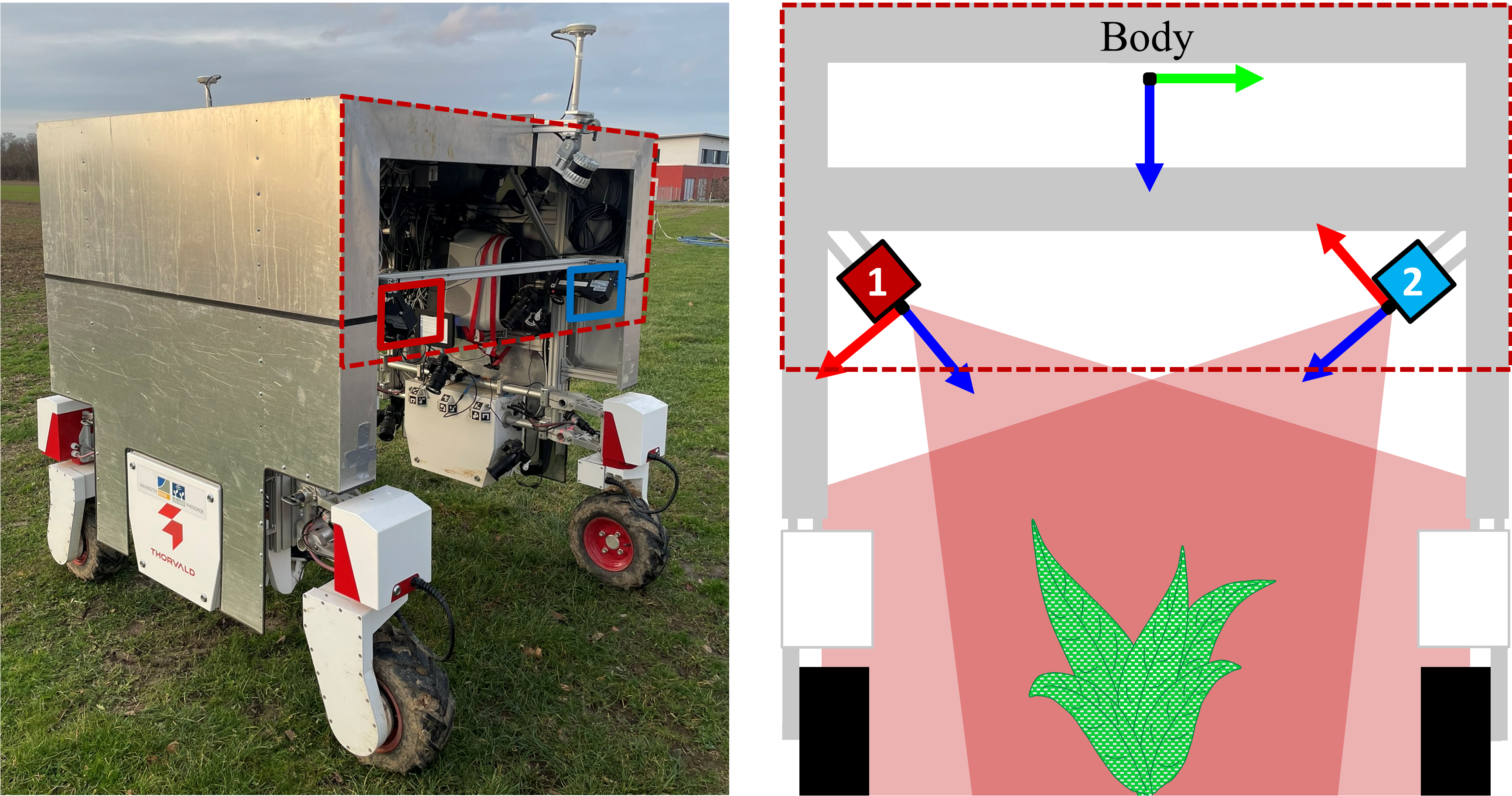
Field phenotyping robot platform used to acquire the dataset

The field robot, used to create the FieldPheno4D dataset, features a Thorvald II base platform with four electric wheels. It is extended by a reversed U-shaped aluminum enclosure measuring 2 x 2 x 2 m to mount the sensors and shield them from sunlight and wind. For trajectory estimation, we equipped the robot with an SBG Ellipse D georeferencing system featuring a dual-antenna multi-GNSS receiver that provides position and heading data at 5 Hz via RTK, and IMU data at 100 Hz. We fuse this loosely coupled data using a factor graph, which is optimized to estimate centimeter-level-accurate trajectories in post-processing. The laser scanning system consists of two industrial-grade laser triangulation scanners LMI Geocator 2490, attached to the inner base frame at the front of the robot. The 2D laser profiles of the scanners point from the left and right into the center of the robot platform. Each scanner acquires laser profiles at a frequency of 200\Hz. The spatial resolution along a single laser profile is 0.5 mm at a distance of 1 meter from the plant. The profile-to-profile distances along the trajectory achieve a resolution of 0.5 mm at a robot velocity of 10 cm/s.

3D point clouds

Timetable
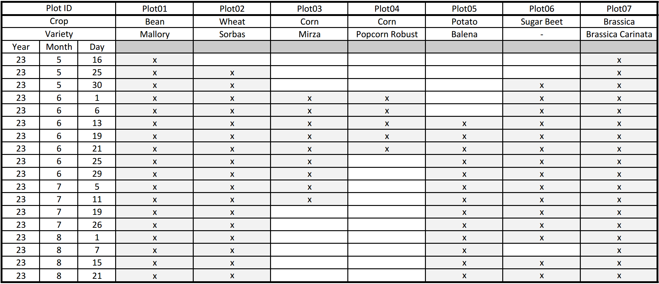
FieldPheno4D measurement timetable

Citation

@data{FK2/HYI2DS_2026,
    author = {Esser, Felix and Klingbeil, Lasse and Kuhlmann, Heiner},
    publisher = {bonndata},
    title = {FieldPheno4D},
    year = {2026},
    version = {V1},
    doi = {10.60507/FK2/HYI2DS},
    url = {https://doi.org/10.60507/FK2/HYI2DS}
}

Acknowledgments

This work has been funded by been funded by the Deutsche Forschungsgemeinschaft (DFG, German Research Foundation) under Germany's Excellence Strategy, EXC-2070 - 390732324 (PhenoRob). This work has been partially supported by the German Federal Ministry of Research, Technology and Space (BMFTR) under the Robotics Institute Germany (RIG).

License

The dataset is distributed under the Creative Commons CC BY 4.0 license, which means you are allowed to share and adapt the dataset as long as you attribute our work. Please see the license webpage for detailed information on the restrictions and terms.